



How to track Indonesia’s 2026 forest and land fires
JAKARTA, thekabarnews.com—Indonesians can now monitor government efforts to control forest and land fires (karhutla) through an online dashboard operated by the National Disaster Mitigation Agency,...

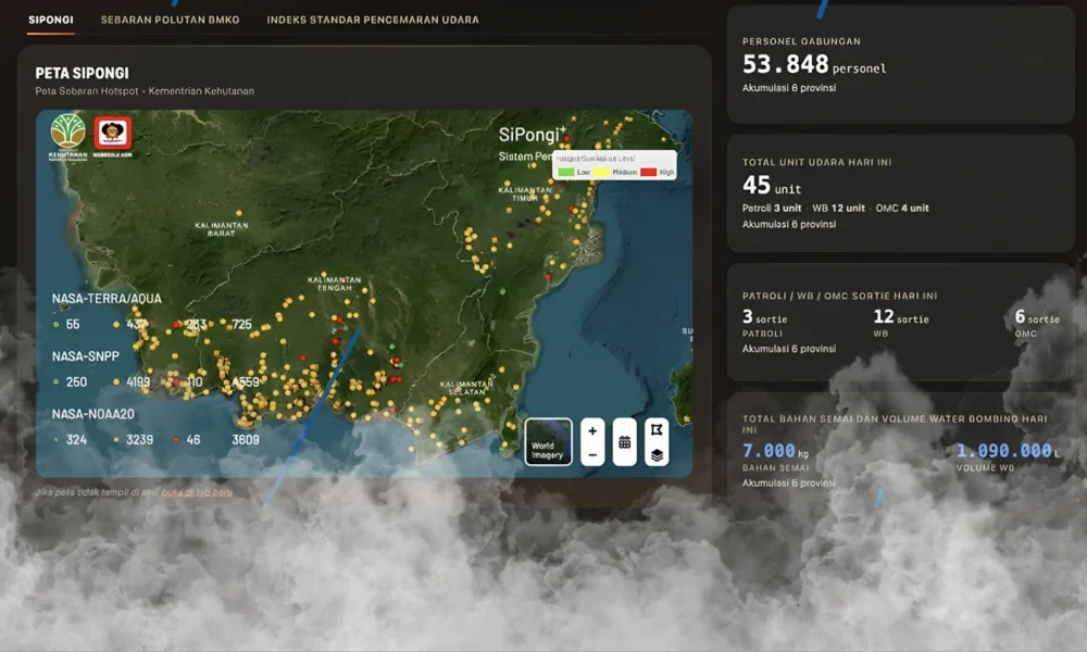
JAKARTA, thekabarnews.com—Indonesians can now monitor government efforts to control forest and land fires (karhutla) through an online dashboard operated by the National Disaster Mitigation Agency, or BNPB.
The 2026 Forest and Land Fire Response Dashboard brings together periodically updated information from six priority provinces: Riau, Jambi, South Sumatra, West Kalimantan, Central Kalimantan and South Kalimantan.
BNPB developed the platform through its Disaster Data, Information and Communication Center (Pusdatinkomben). The agency said it designed the dashboard to give the public a clearer view of fire conditions. It also provides information on the resources deployed in affected areas.
Although the platform supports direct online monitoring, it should not be described as a fully real-time system. The information reflects the latest reports entered by BNPB’s forest-fire response teams and carries a visible update date.
Read also: BNPB deploys 39 helicopters as wildfires spread
Users can view the distribution of satellite-detected hotspots and reported fire spots. The platform also presents estimates of burned land, the area handled by ground and aerial teams, and the number of districts or cities affected.
Operational data include the number of combined personnel and aircraft assigned to the response. Users can also check daily sorties for aerial patrols, water bombing and weather-modification operations.
The dashboard’s Oct. 15 display recorded 53,848 personnel across the six provinces. It also listed 45 aircraft or other aerial units. This includes three patrol units, 12 water-bombing units and four supporting weather-modification operations.
On that update, crews conducted three patrol sorties, 12 water-bombing sorties and six weather-modification sorties. BNPB reported using 7,000 kilograms of cloud-seeding material and 1.09 million liters of water for aerial firefighting.
These operational figures can change when the agency refreshes the platform and should always be reported with their update date.
Read also: Prabowo orders stronger response to Indonesia fires
The air-quality section displays PM2.5 readings and visibility at nearby airports. Other tabs provide pollutant-distribution information from the Meteorology, Climatology and Geophysics Agency (BMKG) and Indonesia’s official Air Pollutant Standard Index (ISPU).
Hotspot information comes from the Forestry Ministry’s SiPongi system, which combines satellite detections. A hotspot indicates a location with an elevated surface temperature; it does not automatically confirm an active fire. Field verification remains necessary to determine whether burning is occurring.
Indonesians can filter the information by province, refresh the display and download available data for further analysis. These features allow residents, researchers and journalists to compare conditions between affected areas. Therefore, users do not need to rely solely on unverified social media posts.
BNPB previously said that in 2026, high fire risks would concentrate in parts of Sumatra and Kalimantan. As of Aug. 9, the agency had recorded approximately 48,889 hectares of burned land across the six priority provinces. At that time, West Kalimantan accounted for the largest reported area.
The dashboard improves public access to official information, but Indonesians should read every figure alongside its date and source. Satellite detections, operational reports and air-quality readings measure different aspects of the emergency and may be updated on different schedules.





No Comment! Be the first one.