



GeoTSat brings AI to satellite wildfire monitoring
JAKARTA, thekabarnews.com—Indonesian satellite service provider Telkomsat is developing its GeoTSat Earth Intelligence platform to transform satellite imagery into practical information for...

JAKARTA, thekabarnews.com—Indonesian satellite service provider Telkomsat is developing its GeoTSat Earth Intelligence platform to transform satellite imagery into practical information for monitoring disasters, forest fires and environmental change.
Telkomsat said on Sunday, September 13, that the platform combines satellite observations with geospatial analysis and artificial intelligence. Potential applications include agriculture, maritime surveillance, mining and regional planning.
Telkomsat Development Director Anggoro K. Widiawan said satellite services now offer users more than images of the Earth’s surface.
“Through GeoTSat, we want to take the use of satellite data beyond simply viewing images of the Earth’s surface,” Anggoro said in a statement received by The Kabar News.
“Earth Intelligence allows the data to be processed into information that is easier to understand, from identifying indications of an event and determining the affected area to monitoring how conditions change over time.”
Telkomsat, a subsidiary of state-controlled telecommunications company Telkom Indonesia, provides satellite-based services across Indonesia and other parts of Asia.
One application, Karhutla GeoTSat, displays the distribution of hotspots and thermal activity across Indonesia.
The dashboard draws data from NASA’s Fire Information for Resource Management System (FIRMS) and presents the information through geospatial visualizations.
NASA says FIRMS provides global near-real-time active-fire data from satellite sensors, with some information becoming available within about three hours of observation.
MODIS detections have an approximate spatial resolution of one kilometer, while VIIRS offers a resolution of about 375 meters.
However, NASA warns that a hotspot does not automatically confirm a forest fire. A thermal anomaly may come from an active fire, hot smoke, agricultural activity or another heat source.
Clouds can also obstruct satellite detection. NASA therefore advises users not to rely on FIRMS alone when protecting lives or property.
GeoTSat also includes a generative AI feature called Fire AI Assistant. Telkomsat said the tool helps users interact with and interpret information displayed on the dashboard.
The company has not publicly released independent accuracy assessments for the assistant.
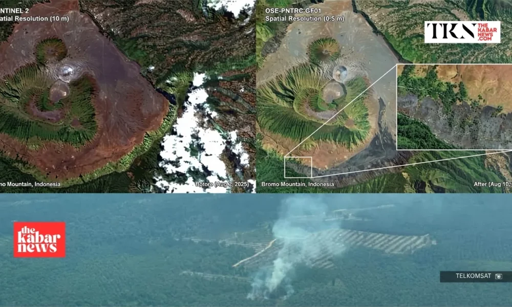
When a hotspot requires closer examination, Telkomsat can use targeted high-resolution imagery through its collaboration with STAR VISION.
The company advertises satellite imagery with a resolution of up to 50 centimeters, allowing analysts to examine smaller surface features in greater detail.
Telkomsat applied this approach to a sample area in Bromo, East Java, following a fire. Its analysis estimated that approximately 1,325 hectares showed indications of fire impact.
The figure represents Telkomsat’s estimate from the analyzed sample, not necessarily an official assessment of the entire affected area.
“Collaboration with technology partners is part of our effort to continue strengthening these capabilities and deliver wider benefits to the public,” Anggoro said.
GeoTSat could shorten the path from detecting a thermal anomaly to selecting an area for closer inspection. Authorities and users would still need field verification, reliable source data and trained analysts before making emergency or regulatory decisions.



No Comment! Be the first one.